

Tissington Hill [Reynard's Cave Hill]
Good walks are even better shared.
SK1552 : A view over Dove Dale
Peter Barr Photo source
Overview
Tissington Hill [Reynard's Cave Hill]
Introduction
Nestled in the heart of the Peak District, Tissington Hill, also fondly known as Reynard's Cave Hill, offers hikers a splendid getaway from the humdrum of urban life. With its marvellous views and manageable routes, it’s no wonder this spot is popular among both novice walkers and seasoned hikers alike.
Geology
Tissington Hill is primarily composed of limestone and gritstone. The region's geological formations are a reminder of its ancient past, once a marine environment teeming with life. Those interested in fossils can often find remnants of ancient creatures on the lower slopes—just be careful not to trip over while you're looking!
Routes
Tissington Trail Approach
- Distance: 5.5 km
- Time: Approximately 2.5 hours
- Difficulty: Easy
This route is ideal for families and beginners. Starting from the Tissington Trail, it provides a gentle ascent to the summit without breaking too much of a sweat!
Reynard's Cave Circuit
- Distance: 7 km
- Time: Approximately 3.5 hours
- Difficulty: Moderate
For the slightly more adventurous, this circuit takes you to the intriguing Reynard's Cave. It's a great way to combine a bit of history and exploration.
Summit Features
Once you reach the summit, you’re greeted by a small stone cairn and breathtaking views of the surrounding countryside. It is a popular spot for a scenic picnic—so bring a scone or two!
Terrain Type
The terrain is a mix of grassy slopes interspersed with rocky outcrops. Be mindful of muddy sections after rainfall, as they can be sneakily slippery—if you’re not careful, you could end up with mud on your boots and a laugh from fellow hikers.
Views
The summit rewards your efforts with panoramic views of the Peak District. Notable sights include Hartington's hills and the captivating limestone scenery of the White Peak. The views are best experienced in spring or autumn, when the surrounding flora is at its most vibrant.
Hazards
When exploring Tissington Hill, take caution on the rocky paths, especially following rainfall, as they can be quite slippery! And a brisk wind may surprise those with a fear of heights—don't let it whisk you off your feet!
Access
Reaching Tissington Hill is easy. The nearest parking can be found at the Tissington Trail Car Park, which is free and includes picnic facilities and public toilets. Public transport options include regular buses from Ashbourne to Tissington, with the town being just 5 miles away—perfect for a day trip!
Facilities
A couple of delightful cafes await in Tissington village, so don your best walking shoes and reward your adventure with a refreshing cup of tea or coffee! For those needing to freshen up, toilets are available in the car park.
History
The name 'Tissington' suggests a connection to Old English roots, indicating 'Tyla's farm'. Meanwhile, Reynard's Cave carries a whiff of folklore, linked to tales of the mischievous fox. Tissington’s rich history includes lead mining and cherished well dressings, showcasing the community's love for water sources.
Conclusion
In summary, Tissington Hill [Reynard's Cave Hill] is a delightful destination for a day in the great outdoors. Whether you're a family hoping for an easy-going trek or an intrepid explorer seeking the thrill of a cave, Tissington Hill has a bit of everything. So put on those boots, grab a map, and enjoy the views that’ll make you want to linger just a while longer. Happy hiking!
Explore routes near Tissington Hill [Reynard's Cave Hill]
Walks starting near this hill. Open a route to check its map, distance and full itinerary.
Tissington Trail: Ashbourne, Thorpe Station and Tissington return
View route
High Peak Trail: Friden, Newhaven Tunnel and Hurdlow Bridge
View route
Carsington Water: full reservoir circuit
View route
Tissington Trail: Parsley Hay, Hartington Station and Heathcote
View route
Route planning notes
These notes describe possible approaches. Check a route's map and access information when planning your walk.
Tissington Trail Approach
A relatively gentle ascent starting from the Tissington Trail, suitable for families and those new to hiking.
Reynard's Cave Circuit
This route takes adventurous souls to Reynard's Cave and is recommended for those looking for a bit of a scramble.
Make a day of it, together
Find someone to share the walk with, or organise a day out along a route you like.
Photo Gallery
View all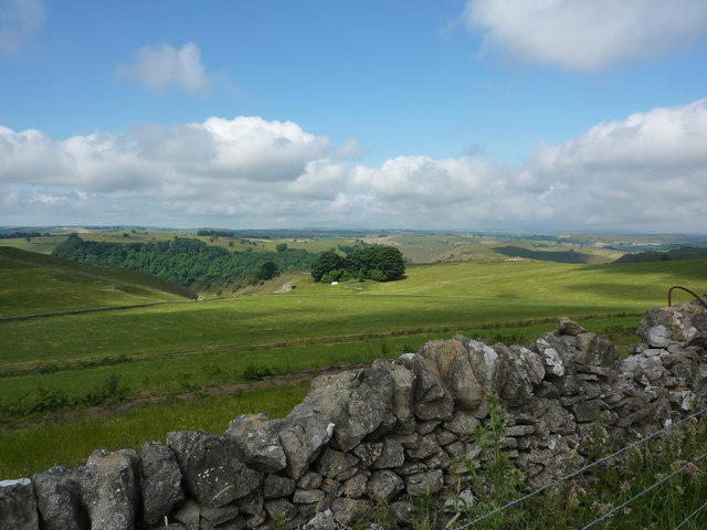 Photo could not load
SK1552 : A view over Dove Dale
Peter Barr
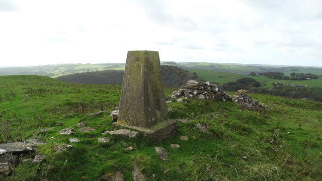 Photo could not load
SK1552 : Reynard's Trig Point with view over Dove Dale
Colin Park
Hill facts and local notes
Classifications
Elevation
369m
1,211 ft
Prominence
95m
Coordinates
53.0712, -1.7760
SK151526
OS Map
119
Explorer: OL24E
At the Summit
The summit features a small stone cairn and an expansive view into the delightful Peak District countryside. It is a somewhat popular picnic spot, so don’t be surprised if you share it with fellow wanderers.
Terrain & Geology
Primarily composed of limestone and gritstone, the geological strata provide a fascinating insight into the area's ancient marine environment. Fossil remains can often be found for the keen eye wandering the lower slopes.
Views & Scenery
From the summit, you can catch spectacular views of the surrounding hills, including the distant heights of Hartington and the striking limestone scenery of the White Peak.
History & Heritage
Name Origin
The name 'Tissington' likely derives from Old English, meaning 'Tyla's farm', with 'Reynard's Cave' referring to the area being famously associated with the folklore of the cunning fox.
Historical Significance
Tissington was a centre for lead mining in the past and is now known for its beautiful well dressings, celebrating water sources from local springs.
Getting There & Facilities
Parking
Free parking is available at the Tissington Trail Car Park, located just off the B5056. Facilities include a few picnic tables and a public toilet.
Public Transport
Buses regularly run from Ashbourne to Tissington, making it accessible for those relying on public transport.
Nearby Facilities
You'll find several charming cafes in Tissington village, perfect for a warm cup of tea after your hike. Public toilets are located in the Tissington Trail Car Park.
Safety Information
Known Hazards
- Beware of slippery rocks and steep sections, especially after rainfall. The area can also be windy, so those with a fear of heights might want to tread carefully!
General Safety Tips
- Check weather conditions before setting out
- Carry appropriate clothing and equipment
- Let someone know your planned route
- Take a map, compass, and GPS device
- Carry emergency supplies: food, water, first aid kit, torch
Hills
Some common questions about the hills answered
Are there group walks up Tissington Hill [Reynard's Cave Hill]?
Many walkers use Walkmates to join or organise walks with others. You can check for group walks around Tissington Hill [Reynard's Cave Hill] through the maps
Are there other walkers around Tissington Hill [Reynard's Cave Hill]?
Activity varies by location and time, but Walkmates lets you see whether others have shared walks or shown interest in this area. Find other people through the walking friends search walking friends for Tissington Hill [Reynard's Cave Hill] search or of course create your own walk for Tissington Hill [Reynard's Cave Hill]
Can I organise a walk to Tissington Hill [Reynard's Cave Hill]?
Yes. If there aren’t any walks listed already, you can create a walk and make it available for others to join.
If you're signed up to Walkmates, you can create a walk to Tissington Hill [Reynard's Cave Hill].
How do I find a walk up this hill?
There are often multiple ways to walk this hill, depending on experience and route preference. Walkmates helps you explore walks and routes that others have shared.
Can I suggest a new route up Tissington Hill [Reynard's Cave Hill]?
Yes. You can suggest or create routes to share with others. Walkmates focuses on the social side of walking, so routes are used to help people organise walks and explore areas together, rather than as detailed navigation tools or route libraries.
Other uses really appreciate knowledgeable walkers sharing their routes. Share your favourite route to Tissington Hill [Reynard's Cave Hill] here
The is an error or something incorrect about this hill. How do I let you know?
We always strive to keep the information on Walkmates as accurate as possible. If you find an error, please let us know through the contact form and we'll aim to correct it as quickly as possible
Community Discussion
Comments
Location
![Tissington Hill [Reynard's Cave Hill] location map](https://cdn.walkmates.com/hill-maps/hill-sources/7739/53.07115_-1.77598.png)
Grid reference: SK151526
View on OpenStreetMapOpens a map in a new tab, centred on the hill.
Nearby Hills
The Roaches
505m

Kinder Scout
636m
Rombalds Moor [Ilkley Moor]
402m

The Wrekin
407m
Winter Hill
456m
No comments yet. Be the first.